Indian Survival In An Era of Vanishing Idealism : Arctic and Antarctic , South China Sea , Middle East , Bay of Bengal , Arabian Sea and Indian Ocean – वीर भोग्ये वसुंधरा
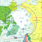
The ruling selfishness of the unipolar world has consigned Kennedy’s ‘We share the same plannet ‘ speech to the dustbin of history and Trumpism is the new normal. All the democratic institutions based on idealism are now falling and the aggressive and unabashed Machiavellian pursuit of self interest has dissolved even the strong and time tested relation ship of Europe and America . Some times it is worse, like attack on Libya for the ostentatious purpose of ‘regime change’ or the case of Arab Spring and Sisi . So it is not a surprise that after the American attack on Iraq on the fake ‘weapons of mass destruction” plea, followed by the French supported attack on Libya , even the middle class powers like Turkey are now flirting with the neo global Khalifa ideas by unilaterally drilling in Cyprus waters, just the way China declared the entire South China Sea as its territory, dislodging the rightful claim of several ASEAN countries like Philippines , Vietnam etc . Russia is now following it in the melting Arctic , much to the discomfort of Norway and other European countries. Europe’s peaceful settlement of North Sea Oil findings is not inspiring China , Russia and Turkey anymore . They are now inspired by US and European conduct in the last two decades of unipolar world .
 Where does India stand in this confusion ?
India earlier followed the European idealism and implemented the International court order giving much of the disputed Bay of Bengal area to Bangladesh . Even Myanmar and Bangladesh navies fought over this territory but all have now peacefully resolved the issue following the self restraint displayed by India . India’s non alignment policy is now irrelevant because every one is seeking protection from the expansionist China . America and Europe do not have the will or means to fight China as there is no matching economic benefit and the Afghan and Vietnam war have taught them the limits of foreign induced proxy wars . Therefore if in the next fifteen years as China consolidates its hold on South China Sea , Russia on Arctic , West in Antarctica ,
what should India do ?
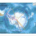
Should we declare the entire Bay of Bengal and Arabian sea area as ours and claim a part of Antarctica ? Somnath temple is located at a spot from where one can or in reach Antartica by sea with no land in between so we have a rightful claim on the Antarctica booty, if any ?
It could be the objective of our militarization and diplomacy although west is not willing to concede or share India’s claim on Antarctica . In absence of our power projection abilities and matching will, we are perceived as weak and even Malaysia , Iran and Turkey are lecturing us on human rights.
On the other hand India has a coastline of 7500 kilometers . So with 500 km economic zone it gives us an area of 2.17 million square kilometrs . We have not able to make any use of it except Bombay High discovery . Now our ONGC Videsh is exploring oil and gas in Iran , Russia , Israel, Sudan etc ignoring the Andaman sea which is so close to Indonesian oil field and could be our gold mine . So what will the extra area in Arctic or Antarctica give us ?
The doctrine of defence is in matching the aggressive postures and powers of the enemy and seeking matching economic potential benefits . Even Pakistan silently added 50000 square kilometers of area by redefining its sea bed near Karachi as India did not file protest in UN in time .We squandered the UN Security council seat when offered and Nepal kings offer to merge with India, Baluchistan etc . We should now follow the pragmatic Chinese and add to our territory from the unclaimed areas . But what about Bangladesh , Myanmar and Thailand in East and Pakistan , Saudi , Oman , Maldives in West . West and China will collude in denying us Antarctica and Arabian sea and part of Indian ocean . Russia will possibly support China and West in denying us any new territory . An alt ernative could be to make the UN or India could unilaterally extend the exclusive economic zone to 1000 kilometers to satisfy the smaller countries .
But only the powerful can demand and protect their rights. India has to become an economic super power and it will automatically become military superpower like China . Only economic and military power will get us our rights in the emerging ‘dog eat dog ‘ world order .
राम नाम की लूट है , लूट सके तो लूट
अंत काल पछतायेगा जब प्राण जायेंगे छूट
Pakistan’s EEZ extension
A victory for the country
Earlier this year, Pakistan managed to have its Exclusive Economic Zone (EEZ) extended by an additional 150 nautical miles (nm) or 278 kilometers (km). EEZ is a sea zone prescribed by the United Nations Convention on the Law of the Sea (UNCLOS) over which a state has special rights regarding the exploration and use of marine resources, including energy production from water and wind. It generally extends to the 200nm (370km) limit. The difference between the territorial sea and the EEZ is that the former confers full sovereignty over the waters whereas the latter is merely a “sovereign right” which refers to the coastal state’s rights below the surface of the sea while the surface waters are considered international waters.
UNCLOS was adopted in 1982 and defines the different maritime zones and regulates marine sovereignty rights and rights of use. Article 76 of UNCLOS defines the continental shelf of a coastal state as the seabed and subsoil of the submarine areas that extend beyond its territorial sea throughout the natural prolongation of its land territory to the outer edge of the continental margin.
The origin of UNCLOS is interesting. Also known as the Law of the Sea Convention or the Law of the Sea Treaty, UNCLOS is the international agreement that resulted from the third United Nations Conference on the Law of the Sea (1973-82). The Law of the Sea Convention defines the rights and responsibilities of nations with respect to their use of the world’s oceans, establishing guidelines for businesses, the environment, and the management of marine natural resources. It was established to ensure that weaker nations’ rights over the sea do not get exploited by more powerful nations.
Earlier, a weak 17th century ‘freedom of the seas’ concept was prevailing, according to which national rights were limited to a specified belt of water extending from a nation’s coastline up to 3nm (6km), according to the ‘cannon shot’ rule.
Later the 12nm (22km) of sovereign territorial waters was established. With the advent of the 20th century, some nations were desirous of extending their national claims to protect fishing rights and indulge in mineral exploration. The League of the Nations, predecessor to the UN, met inconclusively in 1930. In September 1945, US President Truman was the first to extend his country’s sea exploration claims while others followed suit.
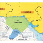
With land based mineral and food sources dwindling, attention was turned to the seas. Subsurface marine life has offered a vast reservoir of food sources over the centuries but the discovery of minerals and energy (gas and oil) reserves whetted the appetite of littoral states to explore and exploit the sub surface treasures. To regulate the claims of various states and avoid conflicts, the UNCLOS was made a potent body. Under the UNCLOS, Pakistan’s EEZ extended to 200nm, covering an area of 240,000 sq km.
Kudos are due to Pakistan Navy (PN), which realising the importance of subsurface exploration and making use of Article 76 of UNCLOS, which also prescribed the procedure for accepting applications for the extension of the EEZ, initiated the move two decades earlier in 1995. PN moved the case through the Ministry of Defence, which led to the Defence Committee of Cabinet (DCC) instituting an inter-ministerial high power Technical Evaluation Committee (TEC) to implement Pakistan’s continental shelf project. Keeping in view the geological nature of project, National Institute of Oceanography (NIO), under the administrative control of Ministry of Science & Technology was entrusted to conduct this project in close liaison with PN’s Hydrographic Department (PNHD). Time was of the essence because UN had set May 2009 as a deadline for early signatories to UNCLOS for submission of claim for area beyond 200 nm.
The last two decades have been a saga of a painstaking process but since the PN was pursuing the case diligently, it was accomplished in a planned and orderly manner. The project was executed in three phases: Desk Top Study (Phase I) in consultation with National Oceanographic Centre, Southampton, UK; Data Acquisition (Phase II) conducted in two parts: first part—French Marine Research Institute (Ifremer) carried out detailed multi-beam bathymetric survey; In second part M/s Seaforth Canada conducted 2D Multi-channel Seismic Survey. PN’s Hydrographic Department independently undertook Geodetic survey of 990 km long Pakistan baseline. Preparation of case for the submission to the United Nation’s Commission on the Limits of the Continental Shelf (Phase III) was completed in consultation with M/s Seaforth, Canada.
Pakistan submitted its claim formally in February 2009 and after a series of presentations to the UN, Pakistan’s application for extension of its continental shelf limits was unanimously accepted thereby extending Pakistan’s sea limits from 200 to 350 nautical miles. This adds over 50,000 sq km of continental shelf, to the existing 240,000 sq km of EEZ, under Pakistan’s jurisdiction. Pakistan will have exclusive rights over the seabed and subsoil resources of the added area. This is a landmark achievement and a momentous event in the country’s history which would bring vast economic benefits through exploitation of extensive natural resources present there. It is a proud moment for the entire nation as Pakistan has become the first country in the region to achieve this remarkable feat.
In order to fully utilise the subsurface resources which are likely to comprise metals like manganese, copper, nickel, cobalt and energy sources comprising oil and gas, Pakistan needs to gird its loins. Exploitation of the rich marine sources enhanced by the extension of the EEZ, which has resulted in the total maritime zone of Pakistan becoming 30 percent of its land area, holds a major promise and opportunity. Dividends from vast EEZ and Continental Shelf area are only possible by optimum utilization of the proffered resources of immense subsurface wealth. Mega projects like the China-Pakistan Economic Corridor (CPEC) demand that Pakistan harnesses all its sources of revenue and energy. A logical step would be to establish an independent Ministry of Maritime Resources, which should not be clubbed under the Ministry of Ports and Shipping, or others.

