
Patriots Forum had earlier published a presentation on Seven Cities of Delhi . Members may view it again at
https://patriotsforumindia.com/seven-cities-of-delhi/
Delhi was made seven times before the present New Delhi became the capital of British India in 1911 . Earliest was the Pandav capital of Indraprasth and the last city was of Shahjahan in the preent Lalkila , Jamamasjid , Chandini Chowk area . The main road of Chandini Chowk was once a canal in Shah Jahan’s time .
The present article by Sohail Hashimi traces the history of Delhi when it was not on the banks of Yamuna . The city’s water supply could not be fulfilled by Yamuna alone . So the East Delhi started getting its water supply from Ganga Canal Water from UP from 2002.
Raw water is being made available to Delhi from Ganga River (240 MGD), Yamuna River (310 MGD),Bhakhra Beas Management Board (140 MGD). About 115MGD of ground water is being explored through Ranney Wells and Tube Wells of Delhi Jal Board.
Dillis without the Yamuna
Author(s): Sohail Hashmi
Magazine ‘ Down To Earth Baoli at Nizammuddin
 August 16 Issue , link not traceable
Sohail Hashmi is a writer and filmmakerFrom the times people began to settle and live in communities, they have chosen river banks and water bodies as sites for settlements. Ancient civilisations grew on the banks of rivers or perennial streams in India, Egypt, China, South America and elsewhere. In many cases, cities continued to grow and prosper, based on roads and markets, despite the rivers responsible for the initial settlement drying up or changing their course.
Delhi—or shall we say the seven Dillis—was located in the plains irrigated by the Yamuna, or the Jamna as it was known throughout most of its pre-colonial history, and its tributary streams. The river divides the present Delhi into two unequal parts, with two-thirds of the city to the west of the river and a third to its east. All the seven cities were located to the west of the river. Why didn’t anyone locate a capital city to the east of the river is a question that needs investigation. To the west of the river the land rises gradually till it meets the outcrops of the Aravallis, while the plains extend almost endlessly east of the river. It was perhaps the combination of a river and hilly prominences not too far away that contributed to the popularity of the area as an ideal location for capital cities.
|
The hilly prominences of the Aravallis to the southwest of the city were to become the location of two of the first four Delhis—the first, Lal Kot and the third, Tughlaqabad. Ala-ud-Din Khilji’s Siri and Mohammad Bin Tughlaq’s Jahanpanah, the second and the fourth of the Dillis, were located in the plains, relatively closer to the Aravallis than they were to the river.
Lal Kot did not have too much to do with the Jamna in meeting its daily water requirements. The Lal Kot-Qila Raipithora area known
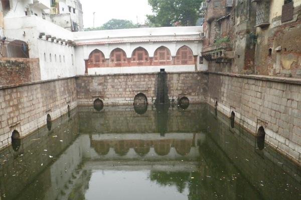
Hauz Khas as Mehrauli depended on deep wells, step wells, huge rain-fed and stream-fed water tanks and a few streams. Some of the wells and tanks have water even today, perhaps not of potable quality. The many step wells, deep wells, the Hauz-e-Shamsi (built in 1230 CE by Sultan Altamash who ruled between 1211-1236), the Rai Pithora ka talao, (excavated about a decade or so ago and difficult to reach now because of all kinds of obstacles, of undergrowth and clashing ownership claims), the channel of the Naulakha Nala, which now carries the untreated sewage of Mehrauli, had clean water flowing till as late as the mid 19th century. Siri, the second Dilli, the capital of Ala-ud-Din Khilji (1296-1316), met most of its water needs from the Hauz-e-Khas, a huge water reservoir commissioned by the Sultan and filled by trapping rainwater and diversion of a few streams. These streams probably included the two that today run through the IIT campus. The reservoir was repaired by Mohammad-bin-Tughlaq. His nephew Firozeshah Tughlaq also carried out extensive repairs on the site, built a madrasa and commissioned his own mausoleum adjacent to the madrasa he had built on the bank of the Hauz.
Thirteenth century Gandhak ki Baoli in Mehrauli (Photographs: Soumik Mukherjee)
The third city, Tughlaqabad, completed in 1321, was closer to the Jamna compared to the other three. An inadvertent contribution to the strategic location of Tughlaqabad was made 90 years earlier, in 1230 CE, when the engineers of Altamash diverted the monsoonal overflow of Hauz-e-Shamsi into the Naulakha Nala. The nala was a tributary of the Jamna and due to this diversion began to have a heavy flow during the monsoons. Some of its overflow began collecting in a depression near the foothills of the Aravallis and over the next 90 years a huge lake was formed. Ghyas-ud-Din Tughlaq, chose this site to build his fortified city in 1321, using the lake as a moat for the south facing wall of the fort.
|
Ghyas-ud-Din Tughlaq located his mausoleum on an island in the middle of the lake while his son built his fort of Adilabad on a hillock to the south of the lake. The two forts were connected to each other with a road that ran atop a barrage that regulated the overflow of the lake to irrigate the fields near Badarpur towards the Jamna. Traces of the sluice gates and an overflow channel can be seen even now near the south-western corner of the Tughlaqabad fort, a little to the east of the main gate of the Kaya Maya Ayurvedic clinic across the road.
Despite their relative proximity to the river and the lake, neither the fort nor the town of Tughlaqabad appear to have used the water of the Jamna or the lake for their daily use, for there were many reservoirs, kunds and baolis inside the fort city and the town.
Due to large-scale construction carried out in recent times in the Bijay Mandal area it is difficult to hazard a guess about how the fourth Dilli—the Jahanpanah, established during 1326-27 CE by Mohammad-bin-Tughlaq (1321-51)—met its water needs. The Jamna, due primarily to its distance from this area, could not have been a source and therefore, wells, manmade or natural reservoirs, perennial and non-perennial tributaries of the Jamna, including the Chiragh Dehli Nala, across which Mohammad bin Tughlaq had thrown a barrage, and several others that criss-crossed the plains, could have been the sources that met the needs of the population residing within the incomplete walls of Jahanpanah.
The other three Delhis, all built on the bank of the Jamna, do not present us with a different picture. Firozabad or Kotla Firozeshah (1350s-1388), Quila-e-Kuhna (1533-1556) and Shahjahanabad (1640-1857) had their backs firmly turned against the river. They were fortress cities that had their own sources of water that included wells, step wells water tanks and, in the case of Shahjahanabad, a canal or two to meet the daily needs of the residents.
The Kotla of Firozeshah has a huge baoli, which has so much water even today that it is used to irrigate all the lush green lawns and flower beds of the fort. There could have been other wells, step wells and reservoirs that supplemented this baoli, but this is only a guess based upon the evidence found in other fortified cities and forts that preceded Firozabad.
Rajon ki Baoli of the Lodhi period in Mehrauli
The Qila-e-Kuhna or Purana Qila was located atop a hillock and for that reason taking water from the river, flowing next to the eastern wall would not have been very practical. The Purana Quila Baoli and the large well located next to the Hamam, both of which have water even now, could very well have been the major sources of water for the fort. The rest of the city spread out towards the north and west. The sources of water for the people can only be a matter of guess work because almost the entire area has been built over.
|
There was plenty of water inside the Red Fort flowing through canals, waterfalls and fountains. There was a Tughlaq period baoli that even today has plenty of water. Outside the fort there was plenty of water in the city. None of it was drawn from the Jamna next door; instead from the Jamna at Hansi and Hissar, 120 km upstream of Shahjahanabad and brought to Delhi through the engineering skills of Ali Mardan Khan, a Persian noble in the service of Shahjahan. The construction of this canal had begun three centuries ago by Ferozeshah Tughlaq. The incomplete canal was repaired by Akbar and Jehangir and during Shahjahan’s time it was extended to Delhi.
Almost every significant temple, mosque and shrine and each mohalla or katra had a well. A few are still in use. The massive baoli in Matia Mahal known variously as Baoli Matia Mahal, Masjid wali Baoli and Banjaron ki Baoli, has so much water that even now the Delhi Jal Board uses its water to meet the water requirement of Matia Mahal and a few other residential localities in Old Delhi. Those who use the name Banjaron ki Baoli for it insist that this baoli was built much before Shahjahanabad and that this place was used for organising fairs and melas in the Pre-Mughal days.
|
With so much water available within the city, is it any wonder that the water of the Jamna was not tapped for drinking or other purposes? The water from the Jamna at Delhi was used only to fill the moat that ran around the Red Fort and the moat that encircled the city running along the Fasil-e-Sheher, the wall around the city.
The large agricultural populations, fisherfolk, washerfolk and others that inhabited the banks of the river, including those who hung around the many temples, would have depended on the river more intimately as they would do even today. The residents of the cities that grew in this region had little or no daily contact with the river, other than boating across it or cremating their dead on its banks.
It is only in the past 120 years or so that we have begun to draw on the resources of the river, and this time has been enough to kill it. A Delhi Jal Board report on water supply in the city has this to say about the history of piped water in Delhi: “The Delhi Water Works was constructed at Chandrawal with a capacity of 4.5 MLD (Million Litres Daily) in the 1890 and the source of water supply was a row of wells sunk along the river. Delhi’s population then was 193,000. After the Delhi Darbar in 1911, Delhi witnessed an increase in population. By 1912, the water demand had exceeded the capacity and necessitated drawing water directly from the river. In 1921, a raw water pumping station was established at Wazirabad and the water was carried to Chandrawal for treatment, where the capacity was raised to 32 MLD. The population served was 304,000. Since then, the capacity of the water works has been gradually increasing in stages and stood at 159 MLD by 1948.”
The rest, as they say, is history.